Hurricane Genevieve becomes first Category 5 storm in Eastern Pacific since 2024
environment
catastrophic
impactful

Hurricane Genevieve becomes first Category 5 storm in Eastern Pacific since 2024

10
(Update: )
shipping company of Singapore
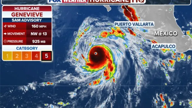
  • Hurricane Genevieve has intensified into a Category 5 storm with maximum sustained winds of 160 mph.
  • The storm is currently moving west-northwest across the Eastern Pacific, generating dangerous swells and rip currents.
  • Despite its strength, Genevieve is expected to weaken by the weekend and poses no threat to land.
Share opinion
1

Story

On July 27, 2026, Hurricane Genevieve rapidly intensified into a Category 5 hurricane, marking a significant event in the Eastern Pacific basin. This storm is notable as it is the first major hurricane of the 2026 season in the Northern Hemisphere, affecting both the Atlantic and Eastern Pacific regions. With maximum sustained winds reaching 160 mph, Genevieve is currently moving west-northwest across the open waters of the Eastern Pacific. The National Hurricane Center has reported that while the storm is expected to remain well out to sea, it is generating dangerous swells that are impacting parts of southern Baja California and the southwestern coast of Mexico, leading to life-threatening rip currents. Meteorologists from the FOX Forecast Center have indicated that the storm is entering an area conducive to further development, as wind shear is predicted to decrease and ocean temperatures are on the rise. The warm water at the surface, along with the warmer water below, provides ample fuel for the hurricane's intensification. However, forecasts suggest that by mid-week, Genevieve will encounter cooler waters, which will initiate a weakening process. As the storm continues to move over progressively cooler waters, it is expected to either weaken significantly or dissipate entirely by the weekend. Despite its current strength, the storm poses no immediate threat to land, allowing residents in the affected coastal areas to remain vigilant but not alarmed. The development of Hurricane Genevieve is a reminder of the unpredictable nature of tropical storms and hurricanes, especially in the Eastern Pacific region. The 2026 hurricane season has begun with a powerful storm, raising concerns about the potential for more hurricanes as the season progresses. The National Hurricane Center continues to monitor the situation closely, providing updates and warnings as necessary to ensure the safety of those in coastal areas. As the storm moves further into the Pacific, the focus will shift to its potential impacts on marine activities and coastal safety, particularly regarding the dangerous rip currents it is generating. In summary, Hurricane Genevieve's rapid intensification into a Category 5 storm is a significant event for the Eastern Pacific, highlighting the ongoing challenges posed by tropical storms in this region. The storm's trajectory and expected weakening will be closely watched in the coming days, as meteorologists work to provide accurate forecasts and safety information to those potentially affected by its swells and currents.

Context

The Eastern Pacific region has a history of powerful hurricanes, with Category 5 storms being the most intense and destructive. These hurricanes are characterized by sustained winds of 157 mph (252 km/h) or higher, and they can cause catastrophic damage to infrastructure, ecosystems, and human life. The Eastern Pacific is particularly susceptible to these storms due to its warm ocean waters, which provide the necessary energy for hurricane formation and intensification. Over the years, several notable Category 5 hurricanes have made their mark in this region, leaving behind a legacy of destruction and a wealth of data for researchers and meteorologists to analyze. One of the most significant Category 5 hurricanes in the Eastern Pacific was Hurricane Patricia in 2015. It reached peak winds of 215 mph (345 km/h), making it one of the strongest hurricanes ever recorded in the Western Hemisphere. Patricia made landfall on the Pacific coast of Mexico, causing extensive damage, particularly in the state of Jalisco. The storm's rapid intensification and subsequent landfall highlighted the increasing intensity of hurricanes in the region, which has been linked to climate change and rising sea surface temperatures. The aftermath of Hurricane Patricia prompted discussions on preparedness, response strategies, and the need for improved forecasting models to better predict such extreme weather events. Another notable Category 5 hurricane was Hurricane Linda in 1997, which also reached peak winds of 165 mph (266 km/h). Linda was remarkable not only for its intensity but also for its longevity, as it maintained Category 5 status for an extended period. The storm remained offshore, sparing land from direct impact, but it served as a reminder of the potential for catastrophic storms in the Eastern Pacific. The data collected from hurricanes like Linda and Patricia have been invaluable for understanding hurricane dynamics, improving predictive capabilities, and assessing the risks associated with future storms. The increasing frequency and intensity of Category 5 hurricanes in the Eastern Pacific raise concerns about the future of coastal communities and ecosystems. As climate change continues to influence weather patterns, it is crucial for researchers, policymakers, and communities to collaborate on strategies for mitigation and adaptation. This includes investing in resilient infrastructure, enhancing early warning systems, and promoting sustainable practices that can help reduce the impacts of these powerful storms. The historical record of Category 5 hurricanes in the Eastern Pacific serves as both a warning and a call to action for all stakeholders involved in disaster preparedness and response.