Maryland braces for first summer heat wave with rising temperatures
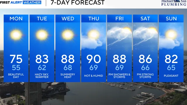
2025-06-03 20:10- Temperatures in Maryland have started in the mid to upper 40s, rising comfortably to the mid-70s on Monday.
- Hazy skies from Canadian wildfire smoke will affect Maryland's weather, reducing visibility and giving a smoky scent to the air.
- As heat and humidity build, Maryland prepares for its first significant heat wave of the year, potentially reaching 90 degrees by Wednesday.
Express your sentiment!
Insights
In Maryland, the weather has turned unseasonably warm, with temperatures expected to approach 90 degrees Fahrenheit as the week progresses. The pleasant conditions began on Monday, June 2, 2025, when temperatures were comfortably in the mid-70s. This refreshing weather will soon give way to a summer-like heat, particularly on Wednesday, when sunny skies will accompany rising temperatures. The state is experiencing hazy skies due to Canadian wildfire smoke, which has been noticeable across the region since June 1, contributing to the atmospheric conditions. This haze is expected to linger, reducing visibility but posing minimal threats to air quality at ground level. As the week advances, Maryland's temperatures will progressively increase, with steady warmth returning on Tuesday, June 3, as afternoon highs reach into the lower 80s. The south-southwest winds at about 10 mph will aid in pushing even warmer air into the state. Starting on Wednesday, both temperatures and humidity will begin to rise significantly, signaling the transition from spring to summer weather. Thursday appears to be the peak of this heat wave, with anticipation of numerous locations experiencing their first 90-degree day of 2025. On Saturday, a strong cold front is expected to approach from the northwest, which may bring scattered thunderstorms as humidity levels build throughout the day. Initially, Saturday looks to start warm and muggy, but the approaching cold front should alter conditions significantly by the evening. Following this front, a cooler and more comfortable Sunday is forecasted, with a drop in humidity levels and clearer skies. This shift is likely to provide a stark contrast to the preceding hot days. Looking ahead into the following week, weather models indicate a possibility of showers and thunderstorms, particularly on Monday and Tuesday. Highs for those days are predicted to hover around 80 degrees. This unsettled weather suggests that Maryland may experience fluctuations in temperatures and conditions as the summer season approaches. Residents are encouraged to stay informed as meteorological predictions continue to update, reflecting changing conditions in the atmosphere and the potential for summer weather patterns to develop.
Contexts
The impact of Canadian wildfire smoke on weather is a significant topic of concern, particularly given the increasing frequency and intensity of wildfires in the region, which can lead to extensive smoke plumes affecting air quality and weather patterns far beyond the immediate fire areas. The interaction of these smoke plumes with the atmosphere results in changes to weather dynamics, such as temperature fluctuations, altered precipitation patterns, and variations in cloud formation. During wildfire events, smoke particles can penetrate the atmosphere, leading to enhanced condensation nuclei, which can influence cloud microphysics and subsequently precipitation processes. This interaction can result in localized storms or shifts in typical seasonal weather patterns, demonstrating the interconnectedness of wildfires and weather systems. Moreover, the transport of wildfire smoke can lead to significant regional and transboundary air quality issues. Pollutants released from burning vegetation, including particulate matter (PM2.5) and various gases, can undergo chemical transformations in the atmosphere and contribute to the formation of secondary pollutants like ozone. These changes not only have direct health implications, causing respiratory issues and other health challenges for populations downwind, but they can also influence broader climatic patterns. The smoke can absorb and scatter sunlight, leading to a warming effect during the day and cooling at night, thus altering the typical diurnal temperature range in affected areas. In addition to air quality effects, the presence of smoke in the atmosphere can lead to substantial changes in weather forecasting models. The emissions from wildfires can introduce uncertainty in predicted weather patterns, making it challenging for meteorologists to provide accurate forecasts. As smoke changes the way sunlight interacts with the earth's surface, it can disrupt assumptions made in weather modeling, potentially resulting in errors in temperature and precipitation predictions. This particularly concerns regions prone to drought or flooding, where the stakes for agriculture, water supply, and infrastructure are high. As we analyze the long-term implications of Canadian wildfire smoke on weather, it becomes crucial to integrate fire management strategies with climate adaptation frameworks. Understanding the linkages between wildfires and weather patterns can inform policies aimed at mitigating the adverse effects of smoke inhalation on public health and preserving ecological integrity. Future research should prioritize maintaining a comprehensive understanding of smoke impacts on atmosphere dynamics and develop predictive models that incorporate varying intensities of wildfire activity to better anticipate their influence on regional and global weather systems.