Severe weather warning issued as tornado watch goes into effect in Maryland
2025-06-08 20:21- A Tornado Watch has been issued for parts of Maryland due to increasing atmospheric instability.
- The watch affects areas south and west of Baltimore, indicating a high risk for severe weather.
- Storms are expected to develop further overnight and into the following day, urging residents to remain vigilant.
Express your sentiment!
Insights
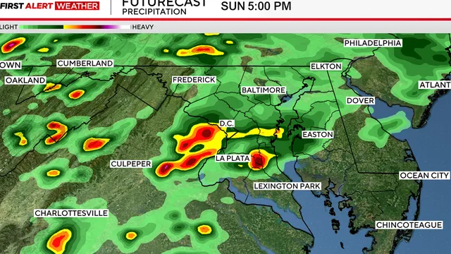
On June 9, 2025, a Tornado Watch was declared for parts of Maryland, specifically targeting areas south and west of Baltimore. This alert was issued as meteorological conditions became increasingly unstable with the approach of a warm front. The affected regions included central Maryland, southern Maryland, and the Lower Eastern Shore where the potential for severe weather was deemed to be highest. Forecasters noted that the warm front was expected to advance northward towards the Baltimore metropolitan area, which would result in a significant contrast between the cooler, stable air to the north and the warmer, more unstable air to the south. The dynamics at play indicated a high likelihood of severe thunderstorms forming in the environment south of the warm front. Authorities warned that the storms could not only bring heavy rainfall but also damaging winds, small hail, and isolated tornadoes. The most significant threat was anticipated along a line from Gaithersburg to Annapolis to Easton to Cambridge; thus encompassing areas greatly populated by residents, including the inner suburbs of Washington and Baltimore, plus St. Mary's, Calvert, Charles, Talbot, Dorchester, and Wicomico counties. The general consensus stated that while storms were possible throughout Maryland, the southern and eastern sections were more likely to experience severe impacts. As the day progressed, forecasters advised that any storms interacting with the warm front had the potential to briefly rotate, greatly increasing the chance for tornado formation, especially owing to the enhanced low-level wind shear present at the boundary. However, meteorological forecasts indicated that as day transitioned to night, the severe threat would begin to wane by midnight as storms lost daytime heating and the atmosphere started to stabilize. Later on June 9, 2025, weather predictions indicated a relatively dry start to Monday with a mixture of clouds and sunshine before an anticipated resurgence in severe thunderstorms, chiefly on Monday night. According to the Storm Prediction Center, much of the region fell under a Marginal Risk for severe storms for late that evening. It was also outlined that during the coming week, a cold front would sweep through the area on Tuesday, further impacting weather patterns. Morning showers and storms were expected, particularly east of I-95, although areas behind the front would gradually experience drier and somewhat cooler air. The forecast showed Monday temperatures peaking in the low to mid 80s before the encroaching front ushered in a brief span of quieter weather midweek. High pressure building from the west indicated a turn toward more pleasant weather, with afternoon temperatures nearing 90 degrees with lower humidity expected later. By the end of the week, another cold front was anticipated to approach Maryland, bringing another wave of storms, urging vigilance amidst an ongoing pattern of unstable weather conditions in the region. Forecasts suggested that both Saturday and Father’s Day on Sunday could witness incidents of heavy rain and thunderstorms.
Contexts
The impact of warm fronts on weather patterns is significant and multifaceted, affecting temperature, precipitation, and atmospheric stability. A warm front occurs when a warm air mass moves into an area occupied by a cooler air mass, leading to the gradual lifting of the cooler air. This lifting process triggers various meteorological phenomena. Typically, the arrival of a warm front results in a temperature increase as the warm air replaces the cooler air beneath it. The transition in temperature can lead to increased humidity levels, which can create favorable conditions for cloud formation and precipitation. As warm fronts advance, they are often associated with a range of weather conditions. Initially, light rain or drizzle is common as the warm air rises and cools, leading to condensation and cloud formation. This can evolve into more significant rainfall, particularly when the warm front is accompanied by an increase in atmospheric moisture. The precipitation associated with warm fronts is generally steady and continuous, in contrast to the more intense, short-lived storms often associated with cold fronts. The gradual nature of warm fronts can lead to prolonged periods of damp and overcast weather, significantly impacting local ecosystems and human activities. Moreover, warm fronts influence atmospheric stability. The cooler air at the surface tends to inhibit significant mixing in the atmosphere, leading to a stable layer beneath the warm, rising air. This stability can contribute to stratiform cloud development, which often manifests as extensive layers of clouds covering a large area. The presence of these clouds can result in reduced sunlight reaching the surface, further impacting temperatures and local climate conditions. In some cases, if the warm front collides with a moist air mass, it can cause the creation of fog, particularly in coastal areas or river valleys where temperature inversions may also occur. Understanding the dynamics of warm fronts is essential for meteorologists, as they play a crucial role in forecasting weather patterns. By analyzing the movement and characteristics of warm fronts, forecasters can provide valuable information regarding expected changes in weather conditions, such as rain, temperature fluctuations, and the potential for severe weather events. Consequently, thorough research and observation of warm fronts contribute significantly to improving predictive models and ensuring public safety in the face of changing weather. This ongoing research will help deepen our understanding of how warm fronts interact with other meteorological systems, enhancing our ability to respond to the challenges posed by changing weather patterns.