Tropical Storm Chantal makes landfall in South Carolina, causing severe weather warnings
2025-07-06 09:20- Tropical Storm Chantal strengthened while approaching the South Carolina coast.
- Landfall occurred early Sunday morning, bringing heavy rains and flash flood warnings.
- Residents are advised to exercise caution as the storm continues to move inland, affecting weather patterns in the surrounding areas.
Express your sentiment!
Insights
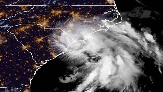
On July 6, 2025, Tropical Storm Chantal made landfall near Litchfield Beach along the South Carolina coast, bringing with it significant weather impacts. Initially, the storm was about 75 miles east of Charleston and was strengthening before making landfall. At its peak, the storm had maximum sustained winds of 60 mph as it approached. Upon landfall, it weakened slightly to 50 mph but maintained its trajectory northward. Emergency management officials warned residents of potential hazards including flash flooding, rough surf, and possible tornadoes in the surrounding regions. The storm is expected to produce heavy rainfall across parts of Northeastern South Carolina and into North Carolina, with forecasts indicating rainfall totals of 2 to 4 inches, and local amounts could reach up to 6 inches, particularly in areas where the heaviest rain occurs. The increased moisture brought by Chantal is expected to aggravate existing local weather conditions, increasing humidity levels in a region that was already experiencing typical summer weather patterns. Warnings for flash flooding have been issued across various counties. The National Hurricane Center reported that conditions created by the storm, such as higher winds and storm surge, along with elevation changes in the land, combined to create risks for flooding in normally dry areas along the coastal regions. Residents were warned not to drive on water-covered roads or ignore road closure signs as conditions worsen. This weather event is occurring as part of a typical pattern of tropical systems that can affect the Southeast United States during the Atlantic hurricane season. While Chantal is expected to weaken rapidly as it moves inland, it highlights the ongoing risks associated with storms during the summer months in the region.
Contexts
Tropical Storm Chantal, which formed in the Atlantic Ocean, had significant impacts on the East Coast of the United States. Initially emerging as a tropical depression, Chantal quickly intensified into a tropical storm as it moved northwestward, gaining strength from warm ocean waters and favorable atmospheric conditions. The storm's trajectory brought it closer to the coastline, raising concerns about potential flooding, wind damage, and hazardous surf conditions. As Chantal approached, local authorities issued warnings and advisories to prepare residents for possible evacuation and ensure infrastructure resilience against the impending storm. The meteorological characteristics of Tropical Storm Chantal included sustained winds reaching up to 60 miles per hour and heavy rainfall. Areas along the East Coast, especially in states like Florida, Georgia, and the Carolinas, experienced torrential rains that led to localized flooding. Coastal regions faced strong surf and rip current warnings, prompting beach closures and safety advisories for water activities. Emergency management teams mobilized resources, deploying personnel and equipment in anticipation of storm-related incidents, and provided continuous communication to keep the public informed regarding the storm's path and expected impacts. As Chantal made landfall, reports indicated that while the storm caused property damage in some areas, the overall impact was mitigated by effective preparedness and response efforts. Communities that actively engaged in storm readiness and had robust disaster management plans in place successfully minimized loss. However, some regions experienced power outages, disrupted transportation services, and temporary evacuations, particularly in low-lying areas susceptible to flooding. Recovery efforts began immediately after the storm passed, focusing on restoring power, clearing debris, and assisting affected residents. In conclusion, the response to Tropical Storm Chantal highlighted the importance of community preparedness and effective communication strategies in managing natural disasters. Evaluating the lessons learned from Chantal aids in better preparation for future storms. Continued investment in infrastructure, and public awareness campaigns, and leveraging technology for forecasting will enhance resilience against similar weather events. The East Coast has a history of tropical storms, and each event underscores the need for adaptive strategies to safeguard communities and reduce vulnerabilities.