California rocked by over 19 earthquakes in the Bay Area
California rocked by over 19 earthquakes in the Bay Area
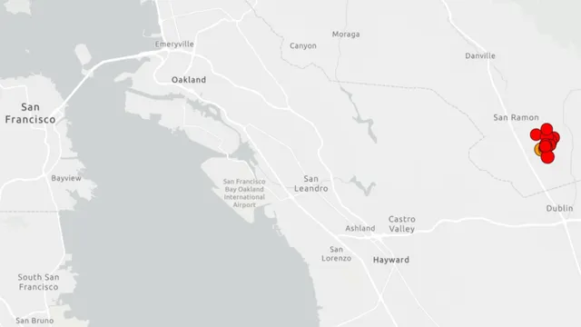
- California's Bay Area experienced a sequence of at least 19 earthquakes on February 2, 2026.
- The strongest quake recorded was a magnitude 4.2 near San Ramon shortly after 7 a.m.
- Residents were relatively safe, with no immediate reports of significant damage or injuries.
Story
On February 2, 2026, California experienced a series of seismic events that included at least 19 earthquakes, with magnitudes reaching up to 4.2 near San Ramon, approximately 30 miles east of San Francisco. The first quake was recorded shortly after 6:27 a.m. local time, followed by a more significant quake at 7 a.m. Residents reported shaking that spread across the Bay Area and into the Central Valley, suggesting that the tremors were felt as far as Sacramento, Stockton, and Modesto. Notably, the magnitude and depth of these quakes indicated a shallow originating point at around 5 to 6 miles deep, characteristic of the fault systems in the region. In addition, this earthquake swarm followed a pattern of increased seismic activity in the Tri-Valley area over the preceding weeks. There were reports of at least a dozen smaller quakes leading up to the significant 4.2 magnitude event. On the Friday before, a 3.1 magnitude quake was also noted, underscoring a period of ongoing tremors that included a total of 91 minor earthquakes recorded since mid-November 2025. The swarm behavior suggests a geological phenomenon where several smaller quakes occur within close timeframes and proximity without a singular large mainshock, which has been an area of research for seismologists. Consequently, the Bay Area Rapid Transit system (BART) experienced disruptions, functioning at reduced speeds for safety inspections as a precautionary measure after reports of tremors. This led to systemwide delays of approximately 20 minutes as train operations were adjusted in response to the seismic activity. Fortunately, despite the quantity and intensity of the earthquakes, there were no immediate reports of serious infrastructure damage or injuries, nor were there any tsunami warnings issued, indicating that the quakes were relatively low in terms of their potential for causing significant disasters. California's geological landscape is inherently prone to earthquakes due to the numerous fault lines crisscrossing the state, notably the San Andreas Fault, which significantly influences seismic activity. Ongoing monitoring by the United States Geological Survey (USGS) provided real-time updates on the quakes, allowing residents to stay informed about aftershock possibilities and subsequent seismic events, which could continue in the hours and days following this series of earthquakes.