Concerns rise as tornadoes strike Kansas City after weather balloon data delays
Concerns rise as tornadoes strike Kansas City after weather balloon data delays
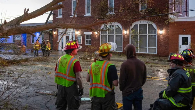
- Five tornadoes struck the Kansas City area, with the strongest rated EF2.
- Changes in National Weather Service balloon launches may have contributed to the lack of early warnings.
- Meteorologists are calling for a thorough evaluation of these operational adjustments to prevent future oversight.
Story
On Monday night, five tornadoes struck the Kansas City area, causing significant concern among meteorologists and residents alike. The National Weather Service (NWS) did not anticipate this tornado threat in its afternoon outlook earlier that day, which highlighted the disconnect between weather forecasts and actual events. Many forecasting offices in the Great Plains had altered their routine weather balloon launches, which previously occurred at 7 a.m., to noon due to staffing issues. This significant change meant that critical data from weather balloon releases was delayed, leaving forecasters without vital information that could have influenced earlier warnings. As a result, many areas were seemingly left unprepared for the severe weather that unfolded that evening. The consequences of these operational changes created an environment where the meteorological models failed to accurately predict the imminent danger of tornadoes forming in the region. Despite the weak forecasting, local meteorological services issued warnings once tornadoes were confirmed to be imminent. The strongest tornado that hit the Kansas City area was rated an EF2 on the Enhanced Fujita scale, and watches were issued approximately half an hour before the first confirmed tornado. This delayed response raises concerns about the effectiveness and readiness of the NWS to adapt to changing operational needs. Additionally, outside meteorologists expressed urgency for the NWS to conduct an adequate evaluation of the impacts stemming from the changes in balloon launch schedules, stating that it seems akin to a real-time experiment lacking thorough assessment mechanisms. As reports of tornadoes surged across the central United States, including a staggering total of 37 reports over the prior three days, forecasters prepared for another round of destructive storms. Federal forecasters warned that the severe weather outbreak was expected to continue into the weekend, particularly on Friday. Conditions remained favorable for fast-developing thunderstorms capable of producing more tornadoes, large hail, and damaging winds. Furthermore, the history of these storms showed a pattern of concentrating activity in the Upper Midwest, with the threat extending into other areas in the coming days. In light of these observations, meteorologists advised residents to stay vigilant and prepared for rapidly changing weather conditions that might present additional risks. Overall, the experience from Monday night illustrates the vital importance of timely data and its impact on predictive modeling in severe weather forecasting.