Severe weather triggers flood watch in Maryland
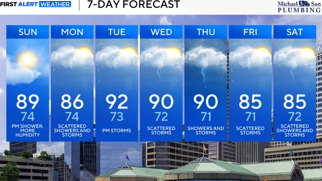
2025-07-07 08:27- Residents in Maryland are facing increased humidity and the likelihood of rain and thunderstorms.
- Flash flooding is expected with Flood Watches issued due to potential heavy downpours.
- The severe weather conditions are expected to worsen throughout the week, particularly on Tuesday and Wednesday.
Express your sentiment!
Insights
Maryland is experiencing an unsettled weather pattern as the Fourth of July holiday weekend comes to a close. With higher humidity levels setting in, the region is preparing for rain and thunderstorms, especially in areas to the east of Interstate 95. The remnants of Tropical Storm Chantal, which moved through the Carolinas and Virginia, are largely responsible for the rainy conditions expected this afternoon. Despite the potential for showers, some neighborhoods may remain dry during the day. Concern is heightened for communities along and east of I-95 where flash flooding is becoming increasingly likely, leading to Flood Watches being put in effect. The anticipated storms are forecasted to develop into heavy downpours, potentially causing severe weather across Maryland, particularly from Monday morning through the afternoon. By midday Monday, temperatures will rise into the mid-80s and storms are expected to become more numerous. Areas receiving repeated thunderstorms could see rainfall totals approaching 5 inches, which poses a threat for flash flooding. The situation has prompted the WJZ First Alert Weather Team to classify Monday as a First Alert Weather Day given the severe weather risks, including the possibility of flash flooding outlined in Flood Watches for several Maryland counties. Weather forecasts indicate that Tuesday will also see the risk of heavy rain and strong to severe thunderstorms during afternoon and evening hours, leading to an urgent need for residents to stay updated on changing weather conditions. As humid air continues to fuel these weather patterns, residents across Maryland, particularly in southeastern Baltimore and Harford counties, are advised to remain vigilant and prepared for storms, which may produce excessive rainfall and pose travel hazards. In that vein, another First Alert Weather Day has been issued for Tuesday with a similar situation expected. The pattern suggests that heavy rainfall could become a recurring theme over the next several days, putting additional strain on already saturated grounds in the region. As temperatures continue to climb to the lower to mid-90s, it will feel even hotter due to humidity levels, increasing the severity of storms that may develop. With conditions conducive to severe weather, monitoring any future weather alerts will be vital for everyone in the area.