Atmospheric river triggers major flooding in Bay Area
2025-02-07 11:00- An atmospheric river brought rainfall and strong winds to the Bay Area on February 4, 2025, causing widespread flooding.
- Unlike other regions, the East Bay experienced less storm damage due to the health of its trees and their dormant state.
- The storm highlights the ongoing risks associated with extreme weather events and the need for preparedness measures.
Express your sentiment!
Insights
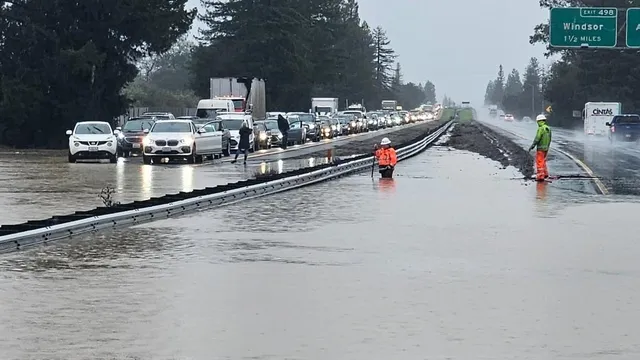
On February 4, 2025, an atmospheric river impacted the Bay Area in California, bringing extensive rainfall, strong winds, and significant flooding. The storm resulted in numerous power outages, affecting thousands of residents. Areas including Santa Rosa, Rohnert Park, and Windsor reported notable flooding incidents, with the overflow of U.S. Highway 101 creating dangerous travel conditions. Emergency services responded to various situations, including a car stranded in floodwaters. The National Weather Service issued warnings about potential flooding and gusty winds across the region. The East Bay region, however, was less severely affected compared to other areas, with healthier trees contributing to reduced storm damage. Arborist Trex Donovan observed that the East Bay's trees were in better shape than in previous years, and many stressed trees had already fallen during prior storms. The time of year also played a role; trees were in a dormant state, resulting in less wind resistance and minimizing risks of falling. Despite the hazardous weather conditions, crews were able to carry out routine tree maintenance services due to the lack of emergencies. The combination of consistent rain and saturated soils heightened the risk of downed trees, especially in areas that received heavier rainfalls. Experts indicated that as the ground became increasingly soaked, the likelihood of root systems failing intensified, creating additional concerns for safety as well as travel. In conclusion, while the atmospheric river led to chaos and inconvenience in parts of the Bay Area, the East Bay's resilience was noteworthy, attributed to the health of its trees and their current state during the storm. As clean-up efforts begin, the region will need ongoing monitoring for additional weather-related impacts as another atmospheric river could follow behind, ensuring that residents remain prepared for potential dangers in the future.
Contexts
Atmospheric rivers (ARs) are critical meteorological phenomena that play a significant role in California's water supply and weather patterns. They are long, narrow corridors of concentrated moisture in the atmosphere, which can transport immense amounts of water vapor from tropical regions to the west coast of the United States. When these moisture-laden air masses encounter the Sierra Nevada mountain range, they are forced to rise, resulting in condensation and precipitation. This dynamic interaction leads to significant rainfall and snow accumulation, which is essential for replenishing California's water resources, particularly given the state's historical challenges with drought and water management. Historically, atmospheric rivers have had profound impacts on California's climate and hydrology. The frequency and intensity of ARs can vary significantly, with some events leading to heavy downpours and flooding, while others contribute beneficially to the state's water reservoirs. Understanding the historical occurrences of ARs allows researchers to analyze trends and anomalies in precipitation data, which is vital for managing water resources and preparing for climate extremes. Studies have shown that certain decades have experienced an uptick in atmospheric river events, which aligns with broader climate change patterns. Increased temperatures can enhance the moisture-holding capacity of the atmosphere, potentially modifying the behavior and impacts of ARs. In addition to their benefits, atmospheric rivers can also pose significant risks, as extreme AR events can lead to severe flooding and landslides. The 2017 and 2019 California winters are prime examples where atmospheric rivers brought over an inch of rain in a short period, causing extensive flooding in urban areas and impacting infrastructure. This has raised concerns regarding the adequacy of current flood management systems to cope with projected increases in extreme weather events due to climate change. Understanding the historical patterns of atmospheric rivers thus not only informs water management strategies but also provides critical data to enhance preparedness and resilience against potential flooding and other hazards. As researchers continue to analyze historical data on atmospheric rivers in California, the integration of advanced modeling techniques and climate projections will play a key role in producing reliable forecasts. By improving understanding of the relationship between atmospheric conditions, climate variability, and precipitation patterns, findings can assist policymakers in devising proactive measures. This includes investing in infrastructure improvements and establishing better predictive systems for managing water resources. As California faces ongoing climate challenges, comprehensive knowledge of atmospheric rivers will remain pivotal in the state's strategy for sustainable resource management.