Magnitude 3.8 earthquake rattles New England residents
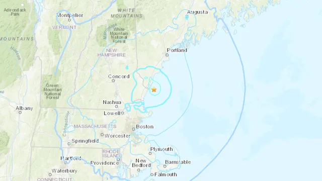
2025-01-27 16:32- A 3.8 magnitude earthquake struck off the coast of New England, specifically near York Harbor, Maine.
- Tremors were felt as far away as Boston, Massachusetts, and reported by residents in multiple surrounding states.
- The earthquake is the strongest to hit the region since a more significant event last year, indicating the rarity of such occurrences.
Express your sentiment!
Insights
On Monday, January 27, 2025, a 3.8 magnitude earthquake occurred off the coast of Maine, affecting multiple regions in New England. The earthquake struck at approximately 10:22 a.m. local time, with the epicenter located roughly 10 kilometers southeast of York Harbor. Tremors were felt across Massachusetts, New Hampshire, and even as far away as parts of Rhode Island and Vermont, showing the extent of the shaking. According to reports from the United States Geological Survey, this event marks the strongest earthquake in the area since a 4.8 magnitude tremor hit New Jersey in April of the previous year, showcasing the rarity of significant seismic activity in the northeastern United States. Despite the strength of the earthquake, local emergency management agencies reported no immediate damage or injuries. Individuals in affected areas described brief shaking that lasted between five and ten seconds, with some experiencing loud bangs during the tremors. Many residents were taken by surprise as earthquakes of this magnitude are infrequent in the region, which is not situated along any major fault lines. John Ebel, a senior scientist at Boston College’s Weston Observatory, indicated that a quake of this nature typically happens once every four to five years. This rarity led to a heightened sense of alarm among residents who experienced the shaking. The U.S. Tsunami Warning Center confirmed that there was no tsunami threat following the earthquake, alleviating concerns that often accompany seismic events in coastal areas. In the aftermath, the Massachusetts Emergency Management Agency emphasized that there had been no reports of structural damage, although residents were advised to remain cautious for potential aftershocks. Ebel mentioned that these aftershocks could be felt particularly in the North Shore area of Massachusetts and coastal New Hampshire if they register around 2.8 to 3.1 in magnitude. As reports continued to pour in, the U.S. Geological Survey collected feedback from residents through their "Did You Feel It?" program, which compiles personal accounts of seismic activity and helps in understanding the earthquake's impact. Approximately 35,000 individuals had contributed their experiences by Monday afternoon, demonstrating a collective curiosity and concern for the phenomenon that rattled their homes. With no significant structural damage reported and the seismic activity deemed within expected ranges for New England, regional authorities remain vigilant but optimistic about the outcomes of this event.
Contexts
The history of earthquakes in New England reveals a relatively low seismic activity when compared to more tectonically active regions of the United States, like California. However, New England is not entirely free from seismic events, as the area has experienced notable earthquakes in its past. Understanding the geological context and historical data provides insights into the frequency, magnitude, and potential risks associated with earthquakes in this region. With the Appalachian Mountains and underlying geology contributing to the seismic landscape, New England is shaped by ancient tectonic processes that continue to influence its seismicity today. The most significant earthquake in New England's recorded history was the 1638 quake, which is estimated to have had a magnitude of about 6.0. This event not only caused damage to structures but was also felt widely across areas, indicating that even moderate quakes can have substantial impacts. Another important seismic event occurred in 1755, known as the Cape Ann earthquake, which is estimated to have reached a magnitude of 6.0 to 6.3. This earthquake was felt as far as New York City and resulted in considerable destruction, altering perceptions of seismic risk in the region. Despite such notable occurrences, the majority of earthquakes in New England are minor, often going unnoticed by the general population. The moderate level of seismic activity in New England can be attributed to the region's geological stability compared to more volatile regions. However, the potential for earthquake hazards remains, particularly as the region has several known fault lines, including the Western Massachusetts Seismic Zone and the Narragansett Bay area. These fault lines are a source of concern due to the possibility of a more significant earthquake occurring in the future. As urbanization increases and infrastructure develops in densely populated areas, the risk associated with seismic events grows, highlighting the importance of preparedness and resilience measures in communities. Research continues to evolve, enhancing our understanding of earthquake risks in New England. Seismologists around the region emphasize the need for ongoing monitoring and studies of seismic activity, as well as public education on earthquake preparedness. While New England does not experience the same level of seismicity as some other parts of the United States, the historical seismic events serve as a reminder that vigilance and preparedness are vital to mitigating potential impacts from future earthquakes.