Severe storm system threatens Eastern US with destructive winds and large hail
Severe storm system threatens Eastern US with destructive winds and large hail
- A severe storm system is sweeping across the Eastern US, fueled by a record heat wave from the West.
- Heavy rain, damaging winds, and large hail are expected, with specific warnings issued for western Pennsylvania, eastern Ohio, and parts of West Virginia.
- Residents should prepare for potential severe weather impacts as temperatures drop significantly after the storm.
Story
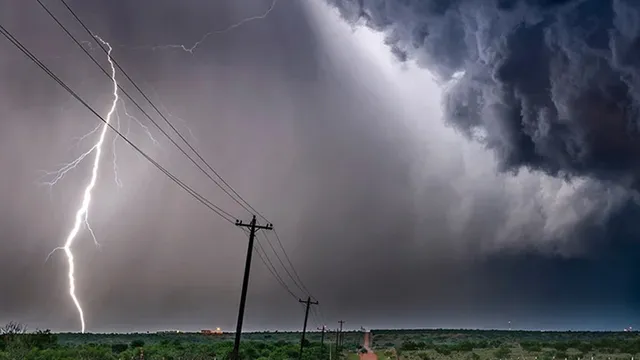
In recent days, a fast-moving storm system has been sweeping across the Eastern United States, bringing heavy rain and the potential for severe weather. This storm is being fueled by an unprecedented heat wave in the West, which has created increased instability ahead of an early spring cold front. Weather forecasters have warned that this cold front will bring conditions conducive to severe storms, including damaging winds and large hail, particularly in regions such as western Pennsylvania, eastern Ohio, and parts of West Virginia. The National Weather Service has issued an upgraded Level 3 out of 5 severe storm risk for these areas, indicating that residents should take precautions against possible severe weather impacts. The storm system is expected to affect the Ohio Valley and then move eastward, impacting the Mid-Atlantic coast and lower Mississippi Valley by Monday morning. The regions facing the greatest risks from these storms include Louisville in Kentucky, Cincinnati, and Columbus in Ohio, where intense thunderstorms are anticipated. According to meteorologists, hail could grow as large as 2 inches in diameter, comparable to the size of an egg, which presents a significant hazard to property and livestock. Wind gusts in the most affected areas could range from 60 mph to over 85 mph, with increased chances of flash flooding due to heavy rains accompanying the storms. Amid this severe weather alert, a flash flood threat has also been issued across Pennsylvania and New York, particularly affecting cities like Philadelphia and New York City. The outlook for the upcoming days remains unsettled, with meteorologists predicting another round of severe storms later this week. Millions are expected to face yet another cold front following these storms, potentially dropping temperatures sharply. As temperatures spike into the mid to upper 60s and even near 90 degrees in some locations, they will plummet dramatically after the storm system passes, with many areas, including parts of the Northeast and Great Lakes, dropping into the 30s and 40s within days. The ongoing extreme weather conditions have raised concerns regarding travel delays and other impacts in regions already experiencing storm damages. As the storm system evolves, it will require continued monitoring, especially in areas hit hardest by earlier storms. This dynamic weather pattern poses a significant threat to personal safety and local infrastructure, making it essential that residents stay informed and prepared for unpredictable changes over the next few days.
Context
analysis strategic global shift global strategic data trends impact geopolitical market data insight policy market shift shift impact economic trends shift global geopolitical policy strategic data global data policy global market data analysis global economic impact impact analysis analysis strategic policy global economic data policy data economic trends data data shift global impact strategic economic impact geopolitical shift strategic analysis economic strategic trends economic market impact market analysis insight shift analysis global geopolitical shift market economic strategic insight data global...